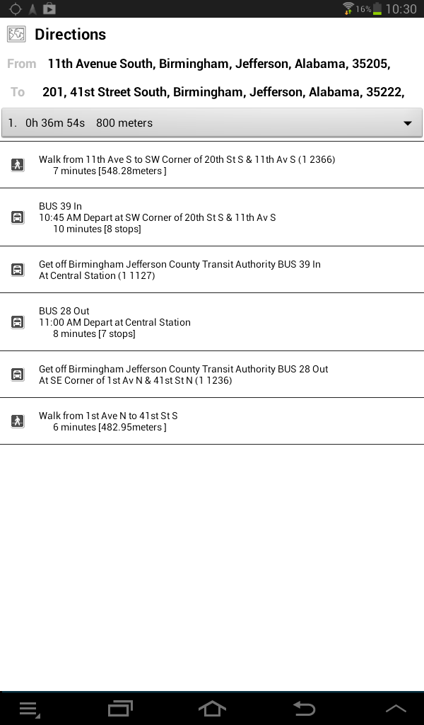
Microsoft’s Bing Maps now includes my GTFS bus data for the Birmingham-Jefferson County Transit Authority (BJCTA). This means you can use Bing Maps to plan all your bus trips through Birmingham on the MAX buses! This is great news! Here’s an example:
Tag: tripplanner
Updated Trip Planner
I have updated the trip planner for the BJCTA Max buses to include new routes. The 1 Express, 45 Express, 44 Montevallo, and 6 Pratt-Ensley have all been completed. You can download the data off of the GTFS Data Exchange.
My Trip Planner already includes the latest data. Or you can download my Android App for free from below.

If you have an iPhone, you can download a 3rd party app called Hop Stop.

Updated GTFS data
I have updated the GTFS data for both the tripplanner and on the GTFS Data Exchange. This adds in support for loops. This means we are now starting to support the DART trolley routes! Additionally, this adds in block support which dramatically improves routing in cases where the rider needs to stay on the bus when the bus changes from an outbound to an inbound route.
For example, the US31 route travels down US31 until it the Galleria Mall. At the Galleria Mall, the outbound trip stops and the inbound trip begins. However, on the inbound trip, the bus leaves the Galleria, and instead of going back the way it came, it loops up through Lorna road before eventually meeting up with US31 and continuing back to Central Station. This means if you are somewhere on US31 and want to go to downtown, you actually need to catch the outbound bus, ride it to the Galleria, stay on the bus as it switches to the inbound route, and ride it to downtown. Without the blocks, the routing algorithm was having trouble switching from outbound to inbound, and assumed the rider must exit the bus and make the transfer. Because the transfer time is less than 1 minute, the algorithm would tell the rider to get off the bus, and wait 30 minutes for the next bus! This is now fixed, and the algorithm now knows that the rider can stay on the bus and continue to Central Station. This should help along any of the routes that have loops.
New version of Android Trip Planner App
I have released a new version of the BJCTA Trip Planner for Android phones. This includes a few small fixes to the geocoding and starts the app centered on BJCTA’s central station, instead of some random location in Nebraska. As always, get it for free from below or in the Google Play store.

MAX Bus Route 40 Available on Trip Planner
BJCTA MAX Bus Route 40, Fairmont, has been completed and is available on the trip planner. The BJCTA Trip Planner Android App will automatically pull in the new route and so will the online trip planner. The 3rd party apps like HopStop will take a while before they update. Â You can find the trip planner at:
BJCTA Routes Available on 3rd Party Apps
As I have been working on cataloging the BJCTA bus stops and generating route data, I have been posting it online at the gtfs-data-exchange for anyone to use. While major companies like Google won’t pick up on this data until it is certified by the agency, smaller 3rd party applications are.
Over the weekend, HopStop updated their app and included my transit data for the BJCTA buses. HopStop has free apps on Android, iPhone, and Windows phone devices. While I have released my own trip planner for android devices (BJCTA Trip Planner), I don’t yet have one for iPhones or Windows phones, so I’m glad to see 3rd party apps incorporating my data!
HopStop Website | HopStop for Android | HopStop for iPhone | HopStop for Windows Phone
If anyone knows of any other 3rd party apps that have picked up my GTFS data, please comment!
BJCTA (Max) Bus Trip Planner for Android
I have created a Trip Planner app for Android phones. This was based on an open source OTP project that I was able to modify and customized to run against my trip planner. Â It costs nothing and has no ads. Please give it a try an let me know if you like it! It is available in the Google Play store under the name BJCTA Trip Planner.

You can learn more about it from the link below.
https://play.google.com/store/apps/details?id=net.line72.bjcta.opentripplanner.android
You can also grab the source code and submit patches from my github site:
MAX Bus Route 45 Available on Trip Planner
BJCTA MAX Bus Route 45, South Bessemer, has been completed and is available on the trip planner. This is one of the most heavily used bus routes in Birmingham and I am excited to have finally cataloged it! Â You can find the trip planner at:
Trip Planner Up
Using Open Trip Planner, I have setup a website for riders of the BJCTA Max Bus in Birmingham, AL to plan out their trips. Â I only have a few of the routes online right now. More routes will be available as their stops are cataloged. Please help test the existing routes and verify the times and locations! You can find the trip planner site below: